


Rochers des parcs

martin.mondeville
User
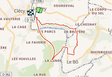

Length
7.2 km

Max alt
158 m

Uphill gradient
173 m
Km-Effort
9.5 km

Min alt
38 m

Downhill gradient
175 m
Boucle
Yes
Creation date :
2025-03-09 14:00:40.0
Updated on :
2025-03-09 16:20:43.602

FREE GPS app for hiking
 SityTrail
IGN / Geographical institutes
SityTrail Plus
The world is yours!
About
Trail of 7.2 km to be discovered at Normandy, Calvados, Le Vey. This trail is proposed by martin.mondeville.
Positioning
Country:
France
Region :
Normandy
Department/Province :
Calvados
Municipality :
Le Vey
Location:
Unknown
Start:(Dec)
Start:(UTM)
685096 ; 5420947 (30U) N.
Comments